If your summer travel plans involve traveling through Ohio and you’re still a fan of paper maps, it’s time you met Bruce Hull.
He’s the guy who’s been injecting visual flair, handy information and a hidden bit of his own family history into Ohio’s road maps for almost two decades. Hull’s artistry has appeared on millions of maps helping drivers navigate the state, which has the nation’s busiest highway system after California, Texas and Florida.
As a layout design artist with the Ohio Department of Transportation since 1989, Hull has creative control over the map’s look and feel. He selects the images, the design, the paper, even the type of fold that’s used.
“Initially, my goal was to go to either New York, Chicago or San Francisco, because those were the big advertising meccas at the time,” said Hull, 60, who studied advertising at the Columbus College of Art & Design. “Then life happened.”
Hull fell in love, got married and had a daughter.
He also happened to like the variety of his job in communications at the Transportation Department, putting together posters, newsletters, in-house publications and visual panels for road, rail and motorcycle maps that, back then, were assembled by an outside consultant.
In those early days, photos were black-and-white, film was developed in labs, layouts were by hand and color was added using sheets of film cut to fit. Anything resembling desktop publishing was a thing of the future.
“Nothing was ever too technical because it was just impossible to do at the time,” said Hull.
The first map he designed on his own came in 2001-2002. That’s also when Hull began what would become an inside joke on the maps: including a photo of his daughter.
“Because we had seat belt laws, I was looking for a stock picture of a kid in a car seat. I found one, but it was $160,” he said with an easy laugh. The department balked at the expense. “So I thought, well, I’ve got a 6-year-old. I’ll just throw her in the back of the van and take her picture.”
Ashley Hull has appeared in every state map since. Unbeknownst to most of the general public, they’ve been watching her grow up — in photos while camping, biking, driving or laughing with high school friends.
“She’s the most famous person you’ve never heard of,” said department spokesman Matt Bruning.
Hull acknowledges that his daughter’s generation — she’s 25 now — has largely abandoned printed maps. In the 1990s, Ohio printed 5.25 million maps on average during each four-year gubernatorial term. By last year, that figure had fallen to 2.25 million.
But, with a Dad who’s the state mapmaker, abandoning paper wasn’t an option for Ashley.
“When she first got her car, she wanted a GPS. So I said, well, you learn to read this first,” he said, brandishing one of his paper road maps. “I showed her these are the interchanges, these little numbers are the distances between interchanges, things like that. In case your power dies, you won’t get lost.”
And those who know Ashley do recognize her from the map, she said.
“It’s not like my picture’s in Time magazine or something,” she said. “But it’s just, it’s cute to have people point out like, ‘Hey I found you in this information center at this park because you’re on the map.'”
If you work anywhere near Hull’s heavily adorned cubicle, you also might be co-opted into helping out. To determine the fold he’ll use, for example, Hull said he slaps a piece of blank paper folded in an accordion or trifold into a co-worker’s hand then watches them try to unfold it. The least cumbersome fold prevails.
The process of creating a new map begins with state cartographers, who produce the actual road map. Then a host of other state departments provide content, such as lists of Highway Patrol posts or state campgrounds, and a message from the governor.
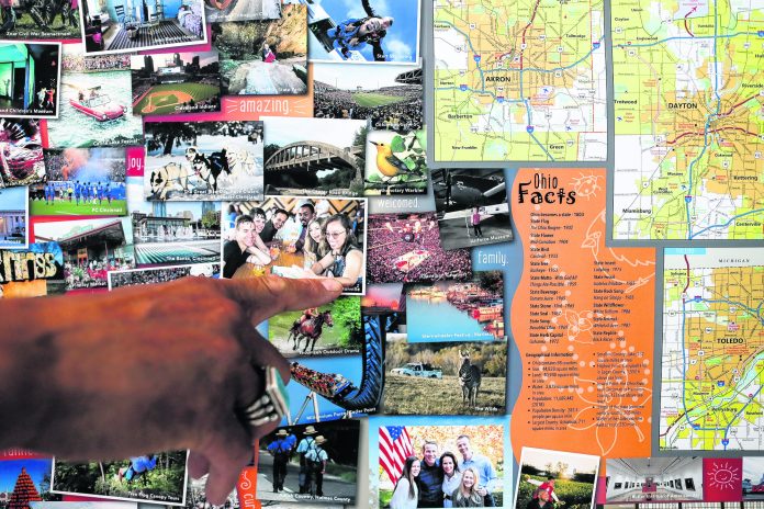
Once all that material is in hand, Hull has free rein over the remaining spaces. One year, his design resembled the front of a refrigerator packed with photos of Ohio attractions. He always works to make featured venues reflect the diversity of the state’s racial and ethnic groups, its rural, urban and natural landscapes and its cultural and recreational offerings.
Another of Hull’s maps featured Ohio emblems, such as the state mammal, bird, insect and flower. Other versions have featured Ohio’s scenic byways and Ohio’s Native American tribes.
During the state’s bicentennial year, in 2003, Hull adorned the map with a timeline of Ohio history. That included another sly family reference: A photo of his great-grandmother, Sophia Mitchell , the first black woman to serve as a mayor in the state.q


